|
Cape Bridgewater
CAPE BRIDGEWATER VIC 3306 - Property No L10143
|
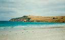
The geological history of the area (volcanic and recent sedimentary) is the basis of a landscape of dramatic coastal forms and subtle hinterland moulding which establish the area as one of high scenic values.
Lieutenant James Grant compiled the initial chart of the south-western area of coastline of Victoria in 1800. Cape Bridgewater was the first place named by Grant within this area.
Edward Henty was the earliest to begin grazing stock on Cape Bridgewater in
... more
|
L10143
|
State
|
